
New Zealand Airspace
Revision: May 22, 2023, at 09:59 PM
Revision notes:
7/12/18
- General amendments/simpification/clarification of airspace descriptions and rules.
Module content
- 1.1 Controlled airspace
- 1.2 Class G airspace
- 1.3 Special Use Airspace
- 1.4 AIP and Notams
- 1.5 VMC and the visual flight rules
- 1.6 Microlight Flight operations
- 1.7 Communication and navigation aids
- 1.8 Distress frequencies and SARSAT
To facilitate safe, orderly use of airspace there are two internationally agreed sets of flight rules (VFR/Visual Flight Rules and IFR/Instrument Flight Rules)– to which all airspace users must adhere – plus several classes of airspace in which aircraft may operate to take advantage of the implied safety within those airspaces.
Controlled airspace is established to protect the flight paths and procedures of IFR aircraft (usually commercial flights) within controlled airspace, air traffic control (ATC) provide (depending on the class of airspace) aircraft and runway separation, traffic information, alerting, wake turbulence and flight information services. ATS is provided by the personnel of Airways Corporation of NZ, using the VHF radio communications networks.
Uncontrolled airspace is not supervised or controlled- pilots must operate on a see and be seen basis following the Visual Flight Rules.
CAA airspace publications
Two useful CAA documents on airspace are:
1.1 Controlled airspace
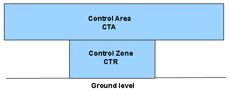
Controlled airspace is sometimes described as ‘an upside down wedding cake’. There are two types of controlled airspace:
- Control zones (CTRs) –the bottom tier of the cake touching the surface of the earth. These protect arriving and departing IFR aircraft at aerodromes.
- Control areas (CTAs) –the upper tiers of the cake. These are established around one or more aerodromes and are designed to encompass the flight paths of controlled flights.
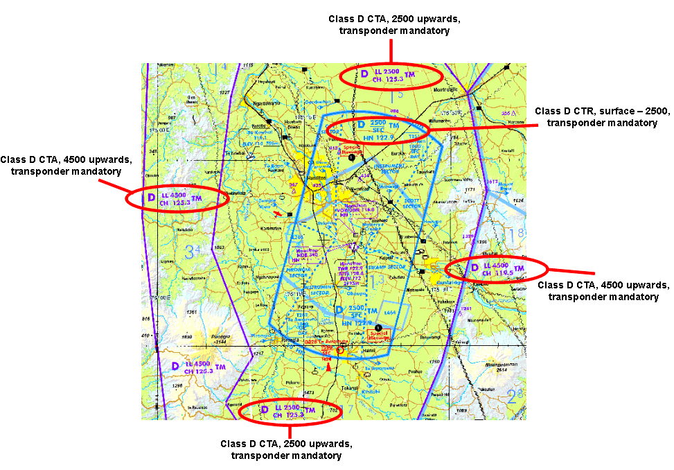
Three of the International Civil Aviation Organisation [ICAO] controlled airspace classes are used in New Zealand; A,C, and D. These classifications refer to the type of service ATC provide to aircraft. All controlled airspace in NZ requires the aircraft to have a radio, transponder and the pilot requires a clearance to enter.
Class A airspace is used to accommodate high-level international air routes. VFR aircraft are not permitted in this airspace.
Class C airspace is applied to CTRs at large international aerodromes, associated CTAs and enroute airspace covering principal domestic air routes. In this airspace IFR and VFR traffic are separated from each other at all times. When VFR aircraft are operating below visual meteorological conditions (VMC) they become termed as Special VFR (SVFR) and are separated from each other when aircraft visibility is below 5km. Where separation is not being provided ATC are required to pass appropriate traffic information about other VFR aircraft. VFR aircraft must maintain their own separation from each other.
Class D airspace normally applies to CTRs and CTAs surrounding regional aerodromes. IFR aircraft are separated from other IFR aircraft, but VFR aircraft are not separated from IFR or other VFR aircraft unless the VFR aircraft are operating as SVFR when the visibility is less than 5km.
| Class A | Class C | Class D |
|---|---|---|
| Upper airspace | Major airports, approach & departure lanes | Regional airports, approach and departure lanes |
| IFR only | IFR/VFR | IFR/VFR |
| Radio required | Radio required | Radio required |
| Clearance required | Clearance required | Clearance required |
| Transponder mandatory | Transponder mandatory | Transponder mandatory |
| IFR/IFR separation | IFR/VFR separation | IFR/VFR separation |
| IFR/VFR traffic information | IFR/VFR traffic information | |
| 5km visibility | 5km visibility | |
| 2km/500 ft from cloud (CTR) 2km/1000ft (CTA) | 2km/500 ft from cloud (CTR) 2km/1000ft (CTA) | |
| 250kts | 250kts |
1.2 Class G airspace
All airspace which is not promulgated as class A, C or D is designated Class G and open without restriction for flight at or below the lower level of any airspace above. Some controlled airspace may have a Class G VFR Transit Lane providing a low level lane undercutting that airspace to facilitate transit or operations without reference to ATC.
Attach:classg.png ![]()
| Above 3000 AMSL or 1000 AGL | Below 3000 AMSL or 1000 AGL |
|---|---|
| 5km visibility | 5km visibility |
| 2km/1000ft from cloud | clear of cloud & in sight of surface |
| below 10,000ft- 250kts | below 10,000ft- 250kts |
To maintain safe separation at airfields in G airspace pilots are required to exercise 'see and avoid' techniques supplemented by VHF monitoring and broadcasting procedures designed to maintain traffic awareness and to manage circuit priorities, where appropriate, in the vicinity of such airfields.
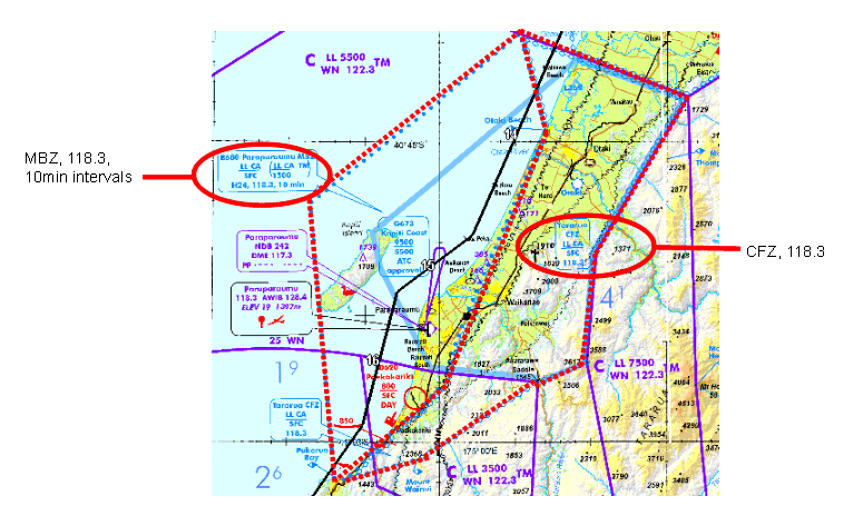
Some airfields will have a designated frequency (marked on the landing chart) for use by traffic in circuit or transiting in the vicinity, otherwise 119.1 should be used. Some class G airspace and associated airfields will be marked as a Common Frequency Zone (CFZ) with a designated frequency for use in that zone. Some class G airspace and associated airfields will be marked as a Mandatory Broadcast Zone (MBZ) with a designated frequency for use in that zone.
Note that while a radio is not mandatory in class G airspace except for MBZs, they are a valuable safety tool. We recommend that you carry and use a radio where practical- even if it is simply to maintain a listening watch for traffic in your vicinity.
| Airfields | MBZs | CFZs |
|---|---|---|
| designated frequency else 119.1 | designated frequency | designated frequency |
| recommended | mandatory | recommended |
| standard circuit/transit calls | on entry and designated intervals | position and intentions |
1.3 Special Use Airspace
As well as MBZs and CFZs mentioned above, there are a number of other special use airspaces.
These extend to varying heights as defined on the VNCs and identified as Restricted (R), Military Operating Area (MOA) , Danger (D), General Aviation Area (GAA) Volcanic Hazard Zones (VHZ) and Low Flying Zones (LFZ) For safety reasons flight into special use airspace may be 'restricted', or some may just be marked 'danger area' as a warning to take extra care.
Restricted areas. Most permanent restricted area are conservation areas of importance to NZ wildlife or jet efflux emitted from power stations. Temporary restricted areas can be designated when considered necessary in the interest of aviation safety, or security, or in the public interest i.e. following a police request in an emergency. These will be NOTAMed. Entry can only be authorised by the ‘administering authority’.
'Military Operating Areas are military areas within which military operations, including live firing and the use of explosives, may take place. MOAs have the same entry and operational requirements as Restricted areas. Flight within these areas may be allowed at times when the restricted area is not activated. ATC will be able to advise if the areas are active especially if that activation is by NOTAM. ATC will generally not be able to issue a clearance to enter unless they are the administering authority .i.e. for MOAs that are used as training areas.
Danger areas usually relate to mining or quarrying sites, and to special aviation activities such as live firing, model aircraft operations etc. danger areas do not have an administering authority as there is no requirement to control access. It is prudent to avoid danger areas or alternatively ascertain the likely danger by contacting the appropriate agency. If you do enter a danger area it will be at your own risk.
Volcanic Hazard Zones are designated where volcanic activity may be present i.e. over Mount Ruapehu .Aircraft are required to operate in VMC by day only. The status and level of activity will be promulgated by NOTAM
| Restricted Areas | Military Operating Areas | Danger Areas | Volcanic Hazard Zones | Low Flying Zones | Parachute Landing Areas |
|---|---|---|---|---|---|
| NZ R... | MOA NZ M... | NZ D... | VHZ NZ V... | NZ L... | PLA NZ P... |
| authorisation required | authorisation required | consider risk before entry | VMC by day only | briefing before entry | consider risk before entry |
1.4 Aeronautical Information Publications and Notams
NZAIP
Airways Corp maintain the NZAIP, which is the primary source of airspace and navigation information. You can access the NZIP online here.
The NZAIP is divided into sections
- GEN
- National Regulations and Requirements
- Tables and Codes
- Services
- Charges
- ENR
- General Rules and Procedures
- Air Traffic Support Services
- ATS Routes
- Radio Navigation Aids
- Navigation Warnings
- AD1
- Aerodrome/Heliports Introduction
- Aerodrome data
- Aerodrome Charts
- Approach, landing, ground, departure and general charts for all registered airfields
- Air Navigation Register
- Permanent Airspace
- Temporary Airspace
- IFR
- Right hand circuits
Those section marked in bold are particularly relevant for the microlight pilot, but we recommend you review all sections for your general knowledge. You should know your way around the NZAIP to be competent planning cross-country flight.
NOTAMS
Notams, derived from the old term 'Notices to Airmen', are issued by Airways Corp and contain "information or instructions concerning the establishment, condition or change in any aeronautical facility , service, procedure or hazard, the timely knowledge of which is essential to persons concerned with flight operations." Notams current at any time are available from the Internet Flight Information Service (IFIS) which we discuss in the 'route planning' module. You should know how to access weather and NOTAMS from the Internet Flight Information Service (IFIS) www.ifis.airways.co.nz or IFISMobile (an APP) to be competent planning a cross-country flight.
AIP Supplements
AIP Supplements contain information that is published in advance that does not require a more timely publication as in a NOTAM. The information in supplements is still relevant to the safe operation of flight and should also be checked prior to flight.
1.5 VMC and the visual flight rules
The two rule sets mentioned are the Instrument Flight Rules [IFR] and the Visual Flight Rules [VFR].
Aircraft operating under the IFR are navigated by reference to cockpit instruments which process data received from ground stations or satellites; IFR flights may operate in both visual meteorological conditions [VMC] or instrument meteorological conditions [IMC] – see below.
VFR flights may only operate in VMC. Most commercial jet operations into or between the major airports would operate only in controlled airspace and under IFR, but turbo-prop and piston engined regional aircraft travelling to or from a smaller city may operate some route sectors in Class G and under VFR. Charter and business aircraft would tend to operate both in controlled airspace under IFR or VFR and in Class G under VFR. Agricultural aircraft would normally be operating in Class G and under VFR. General Aviation training aircraft would tend to operate in and out of a CTR under VFR.
Visual Meteorological Conditions
Microlight and non-instrument rated GA operations may only be conducted in Visual Meteorological Conditions [VMC].The visual meteorological conditions [minima] applicable below 10000 AMSL are:
- Horizontal visibility- 5km. 'Visibility' means the ability to see and identify prominent objects. The problem of course is that there may not be any prominent identifiable objects when flying over featureless areas and, secondly, few people are adept at judging distance from the cockpit.
- Horizontal clearance from cloud – 2km (but see below)
- Vertical clearance from cloud – 1000 feet (but see below)
If operating (in Class G airspace) at or below 3000 feet AMSL or 1000 feet AGL, an aircraft may operate clear of cloud but in sight of the surface.
Visual Flight Rules
The Visual Flight Rules applicable to ultralight, and most light aircraft, operations are primarily 'see and avoid' other traffic, plus the following specifics:
- VMC must be maintained during the entire flight (climb, cruise and descent)
- the flight conducted in daylight hours,
- the pilot must be able to navigate by reference to the ground
VFR on top
All though there is no rules preventing flying above cloud the risks involved are not worth it. Up to 3000ft amsl aircraft must be clear of cloud and in sight of the surface. Above 3000ft amsl you must be 2km horizontally clear and 1000ft vertically clear of cloud. With GPS navigation systems most think it is an acceptable risk but what if for some reason cloud tops extend further than you expected, the GPS fails or you have an engine emergency Taking all into account it is unwise for a microlight aircraft to operate above any cloud cover.
VFR cruising levels
When flying VFR outside a Control Zone, the altimeter sub-scale must be set to to the Area QNH and fly at the designated VFR cruising levels. This helps to ensure separation between VFR/IFR traffic, and between aircraft on converging tracks.
- VFR/IFR separation
- IFR traffic 1000ft levels (5000,6000,7000, etc)
- VFR traffic 1000 plus 500ft levels (5500, 6500, 7500, etc)
- Northbound/Southbound separation
- 270-089 ODD levels
- 090-269 EVEN levels
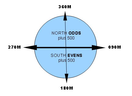
Remember: NOSE- North Odds (plus 500), South Evens (plus 500)
1.6 Microlight Flight Operations
Microlight flight operations are covered largely by CAR Part 91 (General aviation rules) and CAR Part 103 (Microlight specific rules). The main restrictions on microlight flights are:
- Day VFR only- plan your flights to complete well in advance of Evening Civil Twilight.
- No flight over congested areas- plan your route away from congested (built-up or public) areas.
1.7 Communication and navigation aids
Civil aviation radio communications are conducted in the aviation VHF communications [COMMS] band, 118.00 to 136.975 MHz, where, at 0.025 MHz steps, there are 760 channels possible.
The inter pilot air to air communication frequency is 128.95 MHz.
VHF Omni directional Radio Range (VOR) , Non Directional aviation radio (NDB) and Instrument landing systems (ILS) are en-route and approach aids for primarily IFR aircraft use. GPS is becoming the more popular means of navigation for aircraft now and internationally is evolving with different methods of use. Aircraft now have on board systems, if certain requirements are met, that allow approaches in Instrument meteorological conditions (IMC) to weave though mountainous terrain to land at airports like Queenstown with very low minimas.
1.8 Distress frequencies and SARSAT
When a pilot is experiencing in-flight difficulties it is advisable to inform others as early as practical and to advise whether the pilot considers the situation to be an emergency or something less. The frequency on which a distress call ( a MAYDAY transmission) or an urgency message ( a PAN-PAN transmission) is made should be that which is likely to provide a quick response: for example if other aircraft are known to be using a local airfield frequency use that, otherwise use the area frequency, or failing that 121.5MHz.
All microlights flying more than 10NM must be fitted with a 406MHz ELT or carry a 406MHz PLB. These beacons transmit on both 406MHZ (monitored by COSPAS/SARSAT satellites) and 121.5MHz (monitored by international and search aircraft). Beacons with GPS capability transmit the GPS coordinates to the satellite for a virtually instant and accurate fix. Non-GPS beacons are fixed with somewhat less accuracy over a 30 minute period by low-orbit COSPAS satellites.
On receipt of the distress notification from COSPAS, the New Zealand Rescue Coordination Centre first telephones the registered user/s to confirm if this is a genuine emergency activation. If so, rescue action is initiated. The benefit of the 406MHz system is that with the fix information, what would have been a search and rescue scenario becomes a rescue one, with significantly less delay.
end